Autumn is setting in





Conrad Straden–The Tech
It’s been a bit chilly the past few nights. The colors on the trees are changing and the days are getting shorter. As fall begins to set in, we have a few more days in the 70s ahead of us. This morning, a passing shower or two may bring a few sprinkles but otherwise, it will be a warm and mostly sunny day. A cold front will come through this afternoon, with another spotty chance for rain showers, but other than it cooling off a bit, the day will not be spoiled. High pressure sets up on Friday, bringing lots of sun and clear skies. Temperatures this weekend will be running in the mid-to-upper 60s, with lows in the 40s.
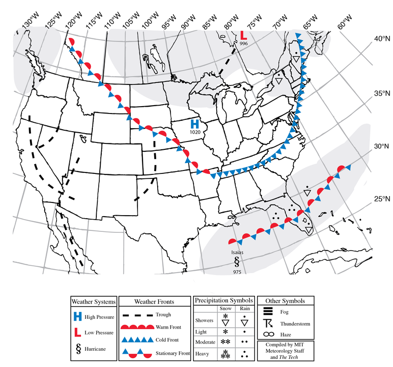
We have had a record quiet hurricane season so far this year, but that all changed today with the formation of Hurricane Isaias in the Gulf of Mexico. Isaias is expected to strengthen to a category 2 hurricane before it makes landfall tomorrow night somewhere along the Florida panhandle or Mississippi/Alabama coastlines. This is the latest date on record that the first hurricane has formed, going all the way back to 1914 — a season with no hurricanes at all.
The remnants of Isaias will push north and east through the Appalachians, reaching us late Sunday night into Monday. Expect some moderate rain on Monday.
To the right is the synoptic chart for 2 p.m. EDT today, Thursday, Oct. 8.
Today: Sunny. High around 73°F (23°C). West winds 10–15 mph with gusts to 25 mph.
Tonight: Clear. Low around 50°F (10°C). West winds 5–10 mph with gusts to 20 mph.
Friday: Sunny. High around 67°F (19°C) and overnight low around 43°F (6°C). West winds 15–20 mph with gusts to 30 mph.
Saturday: Sunny. High around 65°F (18°C) and overnight low around 49°F (9°C). Northwest winds 5–10 mph with gusts to 15 mph.
Sunday: Cloudy. High around 67°F (19°C) and overnight low around 56°F (13°C). Southwest winds 10–15 mph with gusts to 25 mph.